About Me

Tuesday, June 26, 2012

Tombstone - the town too tough to die


Saturday June 23, 2012
We made our way to Tombstone - aka the tourist trap of America.  You have to be prepared to pay for everything - but it was fun and we managed to get our old west family photo (you'll have to wait for the Christmas card to see it), but here are some other photos of some of the things we did!
 Started at the State Court House

 It had some history of Ft. Huachuca as well


 Prison for Michael
Or the gallows?

 Rancher Ty
 Duncan looks like he's going to shoot himself
Remind me not to wear a skirt on the next outing

 Watching actors tell gun slinging saloon tales


 Headed to Big Nose Kate's Saloon for lunch
I had to keep this picture even though it is blurry - because I have a very whiny 7 year old!
 The singer at the saloon
 The Boys at the OK Corral

 Earps above; cowboys below
Tombstone is a city in Cochise County, Arizona, United States, founded in 1879 by Ed Schieffelin in what was then Pima County,Arizona Territory. It was one of the last wide-open frontier boomtowns in the American Old West. From about 1877 to 1890, the town's mines produced USD $40 to $85 million in silver bullion, the largest productive silver district in Arizona. Its population grew from 100 to around 14,000 in less than 7 years. In 1881, it became the county seat of the new Cochise County.
Far distant from any other metropolitan city, by mid-1881 Tombstone boasted a bowling alley, four churches, an ice house, a school, two banks, three newspapers, and an ice cream parlor, alongside 110 saloons, 14 gambling halls, and numerous dancing halls and brothels. All of these were situated among and on top of a large number of dirty, hardscrabble mines. The gentlemen and ladies of Tombstone attended operas presented by visiting acting troupes at the Schieffelin Hall opera house, while the miners and cowboyssaw shows at the Bird Cage Theatre, "the wildest, wickedest night spot between Basin Street and the Barbary Coast."
Under the surface were tensions that grew into deadly conflict. Many of the ranchers in the area were Confederate sympathizers andDemocrats. The capitalists and townspeople were largely Republicans from the Northern states. The fast-growing city, only 30 miles (48 km) from the U.S./Mexico border, was a wide-open market for beef stolen from ranches in Sonora, Mexico by a gang of outlawsknown as The Cowboys. These men were a loosely organized band of friends and acquaintances who teamed up for various crimes and came to each others aid.
The Earp brothers—VirgilWyattMorgan and Warren Earp—arrived in December 1879 and the summer of 1880 . All assumed roles as lawmen at one time or another which led to ongoing conflicts with Ike and Billy ClantonFrank and Tom McLaury, and other Cowboys. After repeated threats against the Earps by the Cowboys over many months, the conflict escalated into a confrontation that turned into a shootout, the now-famous Gunfight at the O.K. Corral. (the above picture is the conflict being re-enacted at 2 pm at the OK Corral).
In the mid-1880s, the silver mines penetrated the water table and despite significant investments in pumps, it became unprofitable to continue costly pumping and mining operations. The city's population dwindled to a low of about 800 in the early 20th century but has stabilized at about 1500 residents. According to 2006 Census Bureau estimates, the population of the city was 1,569. The city's economy today is based on tourism.

And on the way out of town we had to stop at the Sasparilla Emporium - which was really good, btw.  More like cream soda than root beer.  Better have been good for $2.50 a bottle!


Wednesday, June 20, 2012

Chiricahua National Monument

Well, today we drove over 2 hours to go see Chiricahua National Monument
http://www.nps.gov/chir/index.htm

I think we were almost to Mom and Dad Brubaker in Silver City.  There were some patches of road that I drove for a very long time without seeing any other living thing (besides some cows and one random bobcat looking thing).

It is known as the land of standing up rocks.  They call it a sky island - it's an isolated mountain range in the middle of a grassland.  It's kind of crazy to go from cactus grassland to pine trees and canyon like surrounding.

We watched an 8 minute introduction at the visitor center (not the best work of the National Park Service, but still somewhat informative).

Basically the rocks are formed by creating rhyolite (heat ash particles fused together).  Erosion then creates large cracks and water washed away weaker material leaving spires and balanced rocks.
Here's some pictures from our day.

 Ty toke this one - he thought this one looked like a big hand.


This is what happens when Duncan strayed from the path and didn't stick with up.  I think he learned his lesson - one can hope!


 Our hike to the Grottos:
Timon took this one of me!

Duncan took this one of a balanced rock.
 Timon took these 3 of forest fire trees.


Saturday, June 16, 2012

Saturday Trip to Bisbee

Michael had the weekend off - so we decided to check out the copper mining town of Bisbee.  It is pretty close to the border of Mexico.  We thought we'd go see the famous wall.  Here is Duncan by the wall.


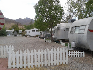
Next we swang by the Shady Dell.  Now this is going back in time.  Pretty cool.
The Shady Dell’s long and epic journey began in 1927 as a place to provide trailer and camping spaces to weary travelers along the famous Highway 80, which stretched from Savannah, Georgia to San Diego, California.  Like its more famous brother Route 66, Highway 80 was a center of travel, exploration and family getaways in the early portions of the 20th century.  Today, the park is a nice mix of practicality and vintage fun-seeking. nine lovely, fully restored vintage aluminum travel trailers await you at the Shady Dell in Bisbee, Arizona. Whether it is the 33 foot Royal Mansion built in 1951 and restored with leopard carpet, martini glasses, Diner-style breakfast booth and phonograph with a collection of 78rpm records, or the 1947 Tiki Bus Polynesian Palace, complete with hand-carved outrigger bar and your own Tiki God, the Shady Dell’s individual trailers will surely send you back to a time when freedom was just another word for jumping in your aluminum house on wheels, finding the Rat Pack on the radio and navigating the open road in search of your own slice of the American Dream.


 Then it was off to our main destination - the Queen Mine Tour.

Bisbee’s Queen Mine was one of the richest copper mines in history. The mine opened in 1877 and eventually closed when Phelps Dodge discontinued mining operations in Bisbee in the mid–1970’s. The Queen Mine opened once again as a tour for visitors in 1976, nearly 100 years after the mine originally opened.
Today approximately 50,000 people a year visit the Queen Mine Tour to commemorate Bisbee’s prosperous mining heritage and experience what it was like working underground where temperatures are 47 degrees year-round.
To take the tour, enter the changing house, pick up your mine token, and get outfitted with your slicker, helmet and miner’s headlamp. Board the mine train and descend into the mine. Tours are conducted by miners who worked in the mines and tell their own stories from personal experiences.


they had you wear these tags -- see Michael's shirt with the pin and tag? They said it was to count how many people came in and came out.  But they had you write your name down next to a number in their book.  Other bloggers suggest that it is to identify your body if the mine collapses. Comforting, eh? Below Michael's shirt is the old time tracking board.  


This picture was taken down in the mine where they showed us some of the blasting equipment.  Ty was really scared that they were going to use real dynamite and blow the place up.  He kept plugging his ears and asking if they were really going to blow it up.  He wasn't a fan of the idea.  Duncan on the other hand couldn't wait for the place to blow!  He kept saying things like, Cool!  and When are they going to blow it up!  Props to the tour guide who spoke to all of us as though we had just been hired to work in the mine.  It was a fascinating living museum, so to speak.


This shows the Lavender Pit - right next to the Queen Mine.  This is where they did strip mining until sometime in the late 1970's.  It was really huge.  Named not for the Lavender rock, but for some mining dude named Lavender.
The Lavender Pit is part of the Copper Queen Mine, run by the Phelps Dodge Corporation from 1879 to 1975. Mining took place in underground tunnels and shafts until 1951 when it was determined by Harrison Lavender, the then-manager of the Copper Queen Branch of Phelps Dodge, that an open pit mine would be an economical way to increase ore yield. The resulting Lavender Pit was mined in 50 foot benches created by loading holes drilled to a 60-foot depth with 1,200 pounds of powder charge. Blasts commonly broke 75,000 tons of rock and were usually shot at 3:25 each afternoon. Mining in the pit stopped in 1974 and all mining operation ceased in the Copper Queen Mine in 1975 when the price of copper plummeted. The abandoned pit covers 300 acres, is 950 feet deep, and is a result of the removal of 351 million tons of material. Since mining operations ceased, the town of Bisbee reinvented itself as an artist community and historical tourist destination. During this reinvention, the Lavender Pit became a tourist destination with rim viewing platforms and guided tours.

Lastly, on our way out of town - had to take a picture at Choppers!  They even have their own facebook page:  https://www.facebook.com/pages/Fast-Lane-Choppers-Cochise-County/299878280068088

Amazing that these places are still around.  Have to say that our first adventure in SouthEast Arizona was a success.